Location
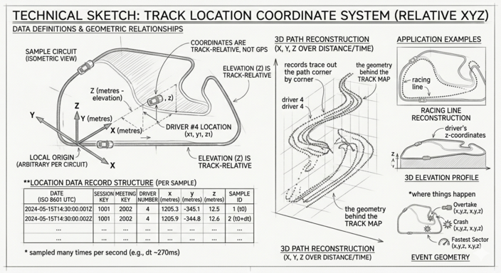
Each record is a single (x, y, z) coordinate for one driver at one moment in time. Sampled
many times per second for the entire session, the records together
trace out the path the car drove — corner by corner, lap by lap.
It's the geometry behind the Track Map:
the driver dots, the racing line drawn on the circuit, and the 3D
elevation views all come from Location.
The coordinates are track-relative, not GPS — meaning the origin and axis directions are arbitrary and differ per circuit. See the "Coordinate system" section below for why this matters.
Fields
| Field | Type | Unit / Range | Meaning |
|---|---|---|---|
date |
string | ISO 8601 UTC | Timestamp of this sample. |
session_key |
int | — | The session this record belongs to. |
meeting_key |
int | — | The race weekend (Meeting) this session belongs to. |
driver_number |
int | 1–99 | Permanent race number of the driver. |
x |
float | metres | Track-relative X coordinate. |
y |
float | metres | Track-relative Y coordinate. |
z |
float | metres | Track-relative elevation. |
Sample record
{
  "date": "2023-03-05T15:00:34.123000+00:00",
  "session_key": 7953,
  "meeting_key": 1141,
  "driver_number": 1,
  "x": 1542.7,
  "y": -823.4,
  "z": 12.1
}
Coordinate system
The coordinates are track-relative, not GPS:
- The origin
(0, 0, 0)and axis orientation are arbitrary and differ per circuit. Don't try to interpret X as east or Y as north — they vary by track. - Distances are metric and consistent within a session. The distance between two samples in metres is a meaningful real-world distance.
- You cannot directly overlay coordinates from two different circuits, even if the units are the same. The frames of reference don't match.
zis elevation in metres relative to the same arbitrary origin. At a flat circuit (Bahrain)zbarely changes; at Spa it varies by tens of metres across a lap.